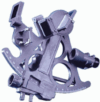
Sekstant do wszystkich zastosowań, z 3-krotnie powiększającą lunetką i śrubą mikrometryczną. 7 przysłon. Wykonany z szarego, odpornego plastyku. W komplecie z pudełkiem i podświetleniem dio...
Racje żywnościowe Seven Oceans dostarczają wysokoenergetycznej diety rozbitkom znajdującym się na szalupach lub tratwach ratunkowych. Są także popularne wśród podróżników, turystów górsk...
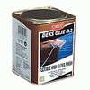
Lakier nawierzchniowy do powierzchni drewnianych nasączonych Deks Olje D1. Zapewnia piękny i trwały połysk, nie maskuje faktury drewna. Zapewnia długotrwałą ochronę. Przystosowuje się do ró�...
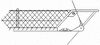
Siatka z nylonu, linki 3 mm. Rozmiar oczka 40 mm. Do mocowania na relingu o wysokości od 40 do 60 cm. Zapobiega wypadnięciu dziecka, psa, a również osoby pracującej na dziobie czy odłożonego ż...
Książka o budowie jachtów żaglowych i motorowych, a także domów na wodzie z laminatów polimerowo - cementowych zbrojonych siatkami stalowymi. Postęp techniczny, a zwłaszcza osiągnięcia chem...
Poradnik dla wszystkich zainteresowanych przygodą z samodzielną budową łodzi. W kilku rozdziałach autor przedstawia różne technologie i materiały. Techniczne informacje są poparte doświadcze...
Uniwersalny futerał wodoszczelny przeznaczony do przechowywania wszelkiego rodzaju urządzeń i przedmiotów, zapewniając im pełną ochronę przy ekstremalnych warunkach pogodowych i w zróżnicowa...
Vademecum żeglarskie to wzbogacona wersja Vademecum żeglarza jachtowego. Zawarta jest w nim tematyka na stopnie żeglarza oraz sternika jachtowego. Znaleźć w niej można materiał potrzebny zarów...
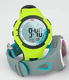
Zegarek startowy marki Ronstan, charakteryzuje się dużymi przyciskami, czytelnym wyświetlaczem. Elastyczna obudowa i pasek z polyurethanu, zapięcie oraz tylna część zegarka wykonane zostały ze...
Po raz kolejny Ewa wysyła nas w bajeczne krainy, o których opowiada w ciepły i pełen zachwytu sposób. Książka Pod żaglami w lodowych krainach, będąca kontynuacją Pod żaglami wśr...
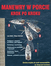
Każdy żeglarz musi umieć manewrować jachtem w dowolnej marinie czy porcie. Książka zawiera wszystko, co trzeba wiedzieć na ten temat. Podczas testów każdy manewr został dokładnie obfotog...
Grecja, pomimo że nie oferuje żeglarzom doskonałych marin ani bogatej infrastruktury w swoich portach jest bardzo popularna wśród wodniaków z całego świata. Dzieje się tak głównie za spraw�...
Przenośny mini głośnik z wbudowanym akumulatorem. Dzięki funkcji Bluetooth 3.0 można odtwarzać muzykę bezpośrednio ze smartfonów, tabletów lub notebooka bez żadnych kabli. Klawisze funkc...
Atlas żeglarski to poradnik skierowany do osób, które chciałyby rozpocząć przygodę z żeglowaniem. Zawiera wszystkie niezbędne wiadomości wymagane w programie szkolenia na stopień żeglarza....